 Back to Historycake Landscape, Life and Mining/Geology Tour - Highway 395 and 14
Palmdale Road Cut — A Slice Through the San Andreas
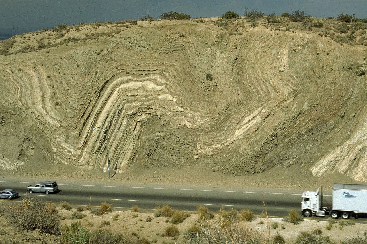
Where Highway 14 sliced through the San Andreas Fault, the canyon walls reveal lakebed shales bent into tight folds — a rare cross-section of the fault that built California.
In the app, this story plays on its own as you reach this spot. This page is the preview.
See the full tourListen
Narration
In the app, the full narration plays when you're on location.
The story
Palmdale Road Cut — A Slice Through the San Andreas
As the freeway cuts through the low hills just north of Avenue S, look at the towering walls on either side. Those crumpled, tilted layers aren't a trick of the light — they're the San Andreas Fault, sliced open and laid bare. When Caltrans pushed Highway 14 through here in the mid-1960s, the bulldozers happened to carve straight across the fault zone, and the result is one of the finest natural cross-sections of the San Andreas anywhere in California.
The eastern wall rises nearly 90 feet. The pale, contorted rock is the Anaverde Formation — shale, siltstone, and gypsum laid down a few million years ago, in the Pliocene, at the bottom of a long, narrow lake. That lake itself was a child of the fault: as two great blocks of crust ground past each other, the land between sagged into a basin that filled with water and fine mud. The gypsum you'd find weathering out of these beds precipitated as that lake slowly evaporated.
Then the same fault that made the basin destroyed it. These sediments are pinned between the San Andreas at the south end of the cut and the Little Rock fault just to the north, and the relentless sideways shear squeezed the soft lakebeds into the tight, almost vertical folds you see — like a rug shoved against a wall. Younger, undisturbed gravels lie flat on top, proof the crumpling came first.
Long before any of this had a name, the Kitanemuk lived across the western part of this valley, hunting and gathering and trading goods over the mountains to the Chumash coast. They knew this ground moved. You're now driving through the seam where the Pacific and North American plates grind past each other — one of the great moving boundaries that shaped California.
On the route
Where it sits
In the app, this stop triggers as you arrive.
Out now
Hear it where it happened.
Get the free app, stand where this happened, and the story starts on its own.