 Back to Saint Francis Dam Driving Tour by History Cake
Stop 7 of 20
Castaic Junction
12:55 AM, March 13th, 11 miles downstream from dam face
Written by historians, never AIResearched & written by Marc Striegel
In the app, this story plays on its own as you reach this spot. This page is the preview.
See the full tourListen
Narration
In the app, the full narration plays when you're on location.
The story
Castaic Junction
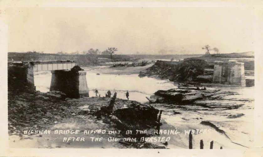
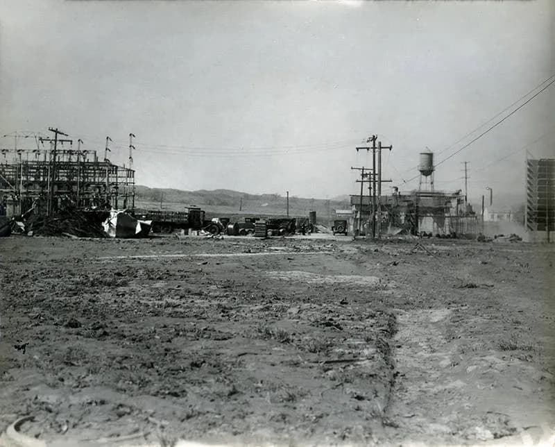
58 minutes after the dam's collapse, a 40 foot brown wall, relentlessly moving at around 12 miles per hour and composed of mud, barbed wire and the debris of ranches and farms far upstream, demolished the steel truss bridge at Castaic Junction. After damaging the Edison substation, the natural topography moves the flood to follow the Santa Clara riverbed and head west toward the ocean.
The road junction at the base of the surrounding hills has always been a meeting place and rest stop of sorts for travelers heading to the ocean west, desert east, san joaquin valley north or the southern third of California.
Castaic is Tatavium Chumash word meaning "our eyes" referring to natural lakes which then supported several area villages north of today's road junction. first hispanicized then anglicized from the Chumash word "kashtuk".
The flood having coming down the San Francisquito canyon to the south will now make its western move after having wreaked havoc on the SCE power station at Saugus -- with the Pacific Ocean, 40 miles and 4 hours distant its destiny. The wall of mud, rocks and debris is between 30 and 40 feet high at this point and moving at over 10 miles per hour and is laying waste to everything before it and demolishing the steel truss bridge over the river at Castaic Junction.
The Del Valle area we are in right now is a part of an east-west synclinal basin located near the eastern end of the Ventura Basin. It is also a part of the Transverse Range region of southern California and its structural trends are therefore predominantly east-west. The area is characterized, structurally, by folding and overthrust faulting with some minor normal faulting.
The formations consist entirely of sedimentary rocks ranging in age from about 20 million years ago to modern day. Beds of the Saugus, upper and lower Pico and Repetto formations are exposed at the surface, and consist of sands, sandstones, siltstones, and shales. Local terrace sands and gravels and alluvial deposits are also present. Two productive oil fields spring up from the faulting, the Del Valle and Ramona fields, still delivering crude oil and natural gas to this day just north of the 126 Santa Clara highway a few miles. See the image of a map showing the two fields along with others to the south when you are not driving to better feel how the pockets of trapped oil and gas align with the faulting and overall geology.
Castaic Junction in 1928 was a sort of transportation hub for travel going south toward los angeles, north on the ridge route or to the west via telegraph road which evolves into the modern 126 highway. It was a place where a tired driver could spend the night before heading on the next leg of their journey. Two large railroad bridges and the main highway across the Santa Clara riverbed were lost in a matter of seconds in the deluge.
Robert McIntyre's restaurant, gasoline station and tourist camp was where you would stay if you could not complete the final couple of hours to Los Angeles. That early morning in March, there were eight automobiles and owners sleeping in or nearby them caught in the flood without warning. They perished along with the elder McIntyre and one of his two sons brother George remaining as the sole survivor. George is quoted as seeing several pairs of headlights coming over a rise in the road and then never coming up again on the side nearer to him.
A poultry buyer from Los Angeles on a night run to Porterville recounted how he outran the oncoming flood in his truck while headed north:
"When I reached Castaic I saw a great wall of water, seemingly about six blocks away...The noise was terrific and I was almost paralyzed with fright. Men whom I afterward learned were Edison company employees came tearing down the highway toward me, shouting to turn back. In some manner I made the turn in the highway at lightning speed and dashed for Saugus. I pushed my truck to full speed, thirty five miles an hour. With that terrible roar behind me and death threatening at every moment, the truck seemed to just creep along...I headed for the hills near Newhall and their comparative safety, held vigil through the night."
On west: Metal-truss auto bridge over the Santa Clara River at Castaic Junction; Auto bridge over San Francisquito Creek where it meets the Santa Clara River; Auto bridge over Southern Pacific Railroad tracks.
On east: Bridge over Santa Clara River; bridge over Bouquet Creek where it meets the Santa Clara River.
Gallery
From this place
On the route
Where it sits
In the app, this stop triggers as you arrive.
You are here
Out now
Hear it where it happened.
Get the free app, stand where this happened, and the story starts on its own.