 Back to Saint Francis Dam Driving Tour by History Cake
Stop 9 of 20
Kemp Siding Edison Road Camp at Blue Cut
1:18 AM; 20-30 ft wall of water; 17.5 miles downstream
Newhall, CAWritten by historians, never AIResearched & written by Marc Striegel
In the app, this story plays on its own as you reach this spot. This page is the preview.
See the full tourListen
Narration
In the app, the full narration plays when you're on location.
The story
Kemp Siding Edison Road Camp at Blue Cut
The flood roared down from Castaic Junction past Del Valle in the Santa Clara River Valley on its path to the Pacific, now heading due west and still over 20 feet high.
It wiped out Joe Gottardi's acres of Pecan orchards as well as his Blue Cut field south of the 126 highway between the blue cut promontory and present day magic mountain in this narrowest part of the river valley. Joe's home, wife and 5 of his six children were all taken from him by the floodwaters. All 1720 acres of agricultural and livestock property he leased from Newhall land and farm were totally destroyed by the thirty foot wall of mud, boulders and debris.
Some 150 Edison linemen had been stringing a power line from downstream Saticoy up to Saugus. They were camped to the south of the present day highway and on the opposite bank of the dry Santa Clara River bed from Blue Cut, the large outcropping of bedrock on the north side where the valley narrows and the highway must curve around it. The floodwaters lashed against the rock and whipped back over the unwarned workers who'd been asleep in their tents, dealing them a double dose of disaster. Eighty-four men, over half of the entire work crew, perished in minutes.
"From our observations," Almer and George Newhall report on behalf of their company, property owner Newhall Land,
"it seems to us that the terrific loss of life and damage caused to this construction camp was due to the backwash of the water when it struck the Blue Cut Promontory and was diverted first north and then southwards back across the track into the body of the stream again. One of the witnesses told us that the water, when the flood first struck them, must have been at least 20 feet deep; in fact the water marks on a remaining telegraph pole there seem to bear out his statement," they wrote.
Indeed, the promontory sent the flood sideways as it was met and a large whirlpool was created. The men in tents had them buttoned up to fight the night chill and many stayed watertight enough that men were sent around a couple of times on the float as they struggled to unzip and get out. A few lucky ones caught the canyon side in one of their revolutions and leaped to safer ground. Muddy, cold and bruised but very much alive.
The Newhalls' report is dated March 24, 1928, and accompanies photographs they shot along the flood path where it ran through their property from Saugus to Piru.
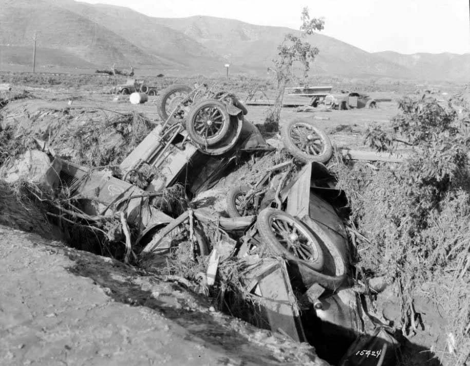
They describe how their photos "give some slight indication of the terrific force with which this backwash of the flood waters engulfed the men (at Kemp), showing respectively a freight car torn from its trucks and tipped over; a group of reels of copper cable weighing approximately 26,000 lbs. each moved from alongside of the railroad track out into the middle of the field 500 feet or more; and a close-up photograph of a few of the wrecked automobiles that belonged to the old construction gang. ...You will notice these automobiles scattered all over the entire field and ... a steam crane being used to right some of them.
"An interesting point is that while the automobile bodies, machinery and tops were very seriously damaged," they note, "we did not see a single instance where one of the tires was broken."
Source: Photographs from the Edward C. Lamb collection
Gallery
From this place
On the route
Where it sits
In the app, this stop triggers as you arrive.
You are here

Out now
Hear it where it happened.
Get the free app, stand where this happened, and the story starts on its own.